| TS1 and TS3: a tale of two sites | |
|---|---|
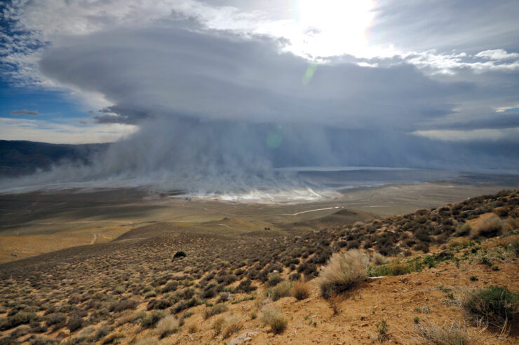
| A wildfire in early July 2007 burnt a large area on the valley floor, including two permanent monitoring sites established close to Blackrock Springs under the Inyo-LA Long Term Water Agreement. Both sites were grass-dominated and mapped as groundwater dependent meadow when established in 1987 and 1988. In one site subjected to continuous water table drawdown, the fire appears to have accelerated desertification. In the other site, which was subject to only a small drawdown, the fire appears to have helped site recovery. Photos below illustrate differences in management and recovery rates.(Photos © Daniel Pritchett unless otherwise noted.) | |
| Site TS1 | Site TS3 |
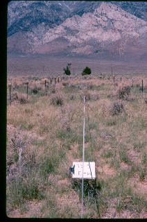
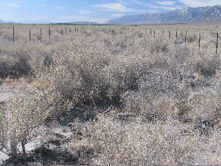
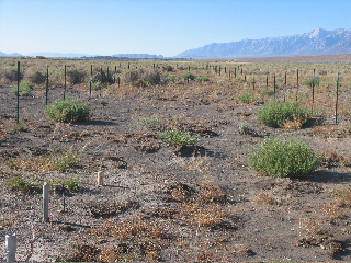
| Site TS1 has been subjected to continuous water table drawdown since it was established. Depth to water (DTW) in site TS1 remained far below the rooting zone for native perennial grasses continuously from 1989 to 2008. (A PDF graph of DTW conditions in TS1 will be available soon.) | Site TS3 was subject to a relatively small drawdown, and the water table first recovered to the grass rooting zone in 1997. Water levels were within the rooting zone of native perennial grasses at the time of the fire. (A PDF graph of DTW conditions in TS3 will be available soon.) |
 |
 |
| Photo courtesy of Inyo County Water Department.
(Above) TS1 in June 1987. Grass is dominant with some shrubs present: Grass cover is approximately 42 percent and shrub cover is approximately 11 percent. |
Photo courtesy of Inyo County Water Department.
(Above) TS3 in June 1988. Grass is dominant: The site has approximately 28 percent grass cover and three percent shrub cover. |
 |
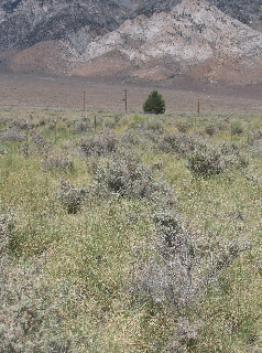 |
| (Above) TS1 on June 23, 2007. Shrubs now dominate the site. Native perennial grass cover has decreased to less than one percent, and shrub cover is approximately 13 percent. | (Above) TS3 on June 23, 2007. Shrub cover has increased, but native perennial grass is still dominant. Grass cover in the top canopy layer is approximately 31 percent, and shrub cover is approximately 10 percent. |
 |
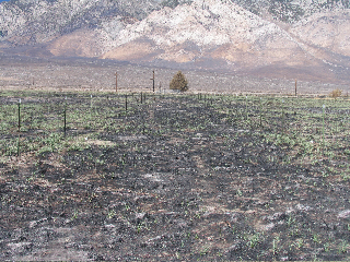 |
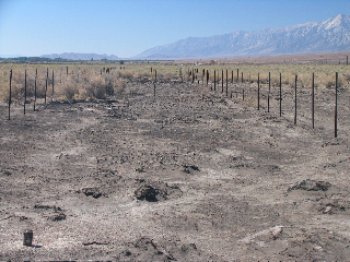
| (Above) Site TS1, July 21, 2007 (approximately two weeks after the fire). No recovery is evident. | (Above) Site TS3, July 21, 2007 (approximately two weeks after the fire). Native perennial grasses have already begun to recover. |
 |
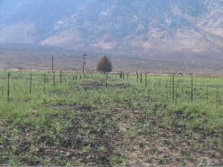 |
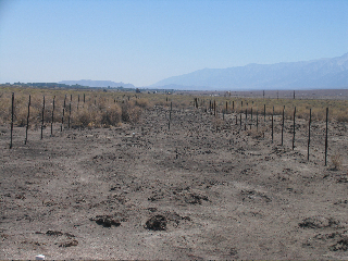
| (Above) Site TS1, August 24, 2007. Less than two months after the fire, the site has lost soil. No perennial grasses are evident. The water table at this site had been maintained far below the grass rooting zone for at least 19 years when the fire occurred. | (Above) Site TS3, August 24, 2007. Native perennial grasses have recovered quickly. The water table at this site was within the grass rooting zone at the time of the fire. |
 |
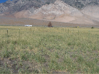 |
| (Above) TS1, August 2, 2008. Vegetation, where it exists, consists primarily of low root-mass, invasive annual weeds. The site is undergoing desertification. | (Above) TS3, August 2, 2008. Cover of native perennial grasses now approaches the amount of cover documented when the monitoring site was established in 1988. |
The California Department of Fish and Game established the Blackrock fish-rearing facility in 1941 at Blackrock Springs, about 12 miles north of Independence. About 8,000 acre feet per year (a.f./yr) of water flowed from the spring through the fish-rearing facility and then directly into the LA Aqeuduct, less than one-quarter of a mile away.
When the Los Angeles Department of Water and Power (LADWP) enlarged its aqueduct and began massive groundwater pumping in 1970 to fill the enlarged capacity, Blackrock Springs dried up. LADWP then used two wells at the hatchery to replace the spring flow.
Unfortunately, LADWP mitigates the loss of the 8,000 a.f./yr spring flow by pumping about 12,500 a.f./yr from its wells through the hatchery and then immediately into its aqueduct. By pumping far more water than ever flowed from the spring, DWP has lowered the water table under rare alkali meadow habitat for hundreds of acres to the south and west.
Monitoring data for the 1991 Long Term Water Agreement show that the meadow habitat is undergoing desertification. Cover of native perennial grasses is declining relative to that of invasive shrubs, and legally established baseline conditions are not being maintained. What is happening is exactly what a century of biology predicts will happen in response to continuous drawdowns.
There is a simple solution: reduce pumping to a volume which matches the former spring flow. This will provide as much water to the fish rearing facility as it was built to use. According to Inyo-DWP hydrologic models, it will also lead to several feet of water table recovery in a few years.
Learn more
• Read about why we decided to challenge the California Department of Fish and Game’s Hatchery and Stocking Program EIR’s assessment of impacts from groundwater pumping for the Blackrock hatchery (explained in our petition for a Writ of Mandate).
• See an article by Mary DeDecker about Blackrock–“The Death of a Spring”–on White Mountain Research Station’s web site.
• Meadow vegetation in the Blackrock area has receded drastically between Charles B. Lee’s survey in 1912 and present-day conditions. To see a brief slideshow illustrating how meadowlands have receded as depth to water increased, click here (low-resolution) or here (medium resolution).You’ll need the (free) Quicktime player to view the show; if you do not have it, you can download it here (Apple site for Macintosh or Windows) or here (Cnet site for Windows).
• In 2006, the Bristlecone chapter of the California Native Plant Society (CNPS) formally asked the Inyo-Los Angeles technical group to consider significant impacts at Blackrock and to modify management there. To see a chronology of what Inyo and Los Angeles have and haven’t done in response to these and further requests, click here. To see comments regarding Blackrock submitted to the Inyo-Los Angeles Standing Committee by Daniel Pritchett of the Bristlecone CNPS on July 9, 2007, click here (cover letter) and here (comments and footnotes).
• To see a 1907 photograph of Blackrock Spring on the web, click here (University of California, Berkeley Water Resources Center Archives).
What you can do
• Contact Los Angeles Mayor Antonio Villaraigosa. Congratulate Mayor Villaraigosa for his public pledge of absolute commitment to honor Los Angeles’ obligations for environmental protection in Owens Valley. Tell the mayor that management around BLK094 is a flagrant violation of this commitment that can easily be corrected.
E-mail Mayor Villaraigosa at mayor@lacity.org, or write him: Mayor Antonio Villaraigosa, City Hall, 200 North Spring St., Los Angeles, CA 90012.
• Contact DWP General Manager Ron Nichols and/or the Los Angeles Board of Water and Power Commissioners. Congratulate Mr. Nichols and the Board on measures to reduce LADWP’s green house gas emissions and conserve water, but tell them that mismanagement at BLK094 is a problem falling through the cracks that requires Mr. Nichols’ personal attention. Until LADWP staff in Owens Valley hear from Mr. Nichols and/or the Board and/or Mayor Villaraigosa regarding this problem, mismanagement will continue.
Address letters to Mr. Ron Nichols, Chief Executive Officer, Los Angeles Department of Water and Power, 111 North Hope Street, Los Angeles, CA 90012, or to the Los Angeles Board of Water and Power Commissioners, Los Angeles Department of Water and Power, Room 1555-H, 15th Floor, 111 North Hope Street, Los Angeles, CA 90012.
To email the LA Board of Water and Power Commissioners, click here.
• Contact Inyo County Supervisors. Tell Inyo County Supervisors that current management at BLK094 sells Inyo County short. With proper groundwater management there is plenty of water for sustaining both the meadow at BLK094 and the Blackrock fish hatchery. Inyo Supervisors have as much responsibility as LADWP for ongoing mismanagement and as much power to remedy the problem.
 |
|
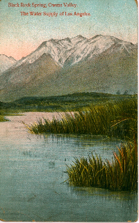
| A 1909 postcard from “Black Rock Spring, Owens Valley. The Water Supply of Los Angeles.” Photo courtesy of Michael Prather. |

