Note: The article below was written in 2005. In 2013 only a few edits were necessary. The problems discussed have only worsened since the article was first posted. Also see our Blackrock and Symmes Disaster pages or our groundwater brochure [PDF]
Introduction
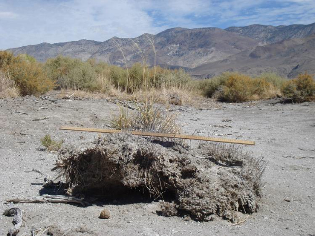
Figure 2. This pedestal sports living sprigs of meadow bunchgrass, Sporobolus airoides, in this photo taken in 2007. The site, near Aberdeen, is a somewhat-recovered meadow that suffered the effects of groundwater pumping from about 1987-1997. Water table recovery allowed dormant grasses to resprout, but the local environment experienced soil loss, leaving some living grasses and shrubs on pedestals. Please click here for a PDF of Figure 1 and Figure 2.
In our efforts to measure and monitor current vegetation conditions throughout Owens Valley, my coworkers and I often observed tangible reminders of the valley’s past. This little article describes one interesting but disturbing relic we encounter: pedestaled remnant bunchgrasses (see figures).
An explanation of their origin comes from knowledge of the valley’s ecological past. A century ago, meadows covered much of Owens Valley. Verdant grasses dominated the area where Sierran alluvial fans meet the valley floor (approximately where Highway 395 runs through Owens Valley today). In the very early 1900s, US Geological Survey engineer and LADWP consultant Charles H. Lee mapped and characterized the valley floor vegetation and hydrology.
In his intensive study of Owens Valley south of the Poverty Hills (published in 1912), Lee showed vast expanses of what he called “grass land,” and he noted this vegetation type predictably occurred when the water table averaged 8 feet (2.4 meters) or shallower.
Over eons, geologic and hydrologic processes combined to create a broad and persistent zone of shallow groundwater at the fan toeslopes, and, thanks to the availability of this fresh water source, grass and other herbaceous species established and flourished. High cover meadow vegetation was an anomaly in such an arid valley because the meager precipitation characteristic of the valley floor (average ~ 5.5 inches or 14 cm), cannot, by itself, support much vegetation cover.
Many changes have occurred since the early 1900s. The Los Angeles Aqueduct was constructed, and groundwater pumps were installed in the meadows to extract and export the readily available shallow groundwater. One area that was heavily pumped in the early part of the 20th century was the alluvial fan toeslope south of Independence (south of Mazourka Canyon Road and east of Highway 395, today referred to as the Symmes Shepherd wellfield). The area was pumped heavily again in the 1960s and 1970s.
By the time LADWP botanists arrived in the area to map and characterize the vegetation in the mid 1980s, the meadows were mostly gone. In place of meadow, they found expanses of barren soil, and acre upon acre dominated by the invasive shrub, Nevada saltbush (Atriplex lentiformis ssp. torreyi).
Pumping had dried springs and seeps in the area and lowered water tables beyond 8 feet. Thus, human activity had converted biologically diverse native meadow to depauperate stands of opportunistic species, a process termed “desertification” in the scientific literature.
The goal of management under the Water Agreement is to prevent further loss of cover and adverse changes with regard to the species that existed on sites in the mid 1980s. Under this management approach, it’s unlikely native meadow will reestablish in the altered parts Symmes Shepherd (Figure 1). Here, Lee’s meadows are relegated to history.
Even today, however, traces of that history remain. When we measure and examine vegetation in the field, we often observe senescent remnants of the common meadow bunchgrass, Sporobolus airoides. Sometimes, these clumps of plant material are obscured among the branches of saltbush, other times, they conspicuously dot the barren soil patches. Even though functionally dead, and no doubt in such a state for several decades, roots of these grasses continue to cling to and bind the soil.
Despite their tenacious characteristics, forces continue to act, erasing other signs of the former meadow. With dewatering, most herbaceous species die and disintegrate and soils dehydrate. Formerly wet soils, having been wet for perhaps centuries, tend to have considerable amounts of accumulated, light-weight organic matter. When these soils dry, they are particularly vulnerable to wind erosion. Owens Valley winds readily erode and redistribute the dry, loose soil.
As shown in Figure 1, erosion has taken its toll on the former wet meadows that used to exist south of Independence. In this area, we find the old bunchgrass clumps on pedestals. The crowns of these plants used to be relatively flush with the ground surface when the meadow was intact. However, the dark, organic soil that wasn’t held in place by persistent bunchgrass roots has eroded away. The pedestaled bunchgrass in the picture demonstrates that this site has experienced at least 10 cm of soil loss since the meadow died.
This type of erosion is evident in other parts of the valley as well, including adjacent to a Inyo/DWP monitoring site (see Figure 2 above). Here, the area was mapped as meadow during the 1986 Water Agreement baseline period. During the late 1980s, however, heavy pumping drew water tables down well below the grass rooting zone.
The Inyo County Water Department documented that live grass cover diminished greatly during the decade water tables were deep. However, in the late 1990s, water tables began to recover in this area, and grasses came out of dormancy (Owens Valley Monitor 1997, p. 23, “New Sprouts”). Nevertheless, periods of vegetation die-back took its toll on the local environment. Although live grass helps hold this pedestal together, the soil around it has blown away.
Sights like these are reminders of what’s been lost in Owens Valley, and they serve to warn of changes that can occur over relatively short time periods. These examples suggest desertification may occur within perhaps two human generations, as the result of altering and removing critical, life-giving water resources. Now, scattered, pedestaled grass clumps throughout the valley serve as mini-monuments to the site’s ecological past.
The capture of Owens River by the Los Angeles Department of Water and Power (LADWP) in the early 1900s, the consequent drying of Owens Lake, and the destruction of Owens Valley agriculture are relatively well known. Less known is that many groundwater-dependent resources such as springs, wetlands, and thousands of acres of alkali meadows survived the capture relatively intact.
In 1970, LADWP started pumping massive amounts of groundwater to fill its newly enlarged aqueduct. Impacts to groundwater-dependent ecosystems were immediate, and Inyo County filed suit under the California Environmental Quality Act. Nineteen years of litigation later, Inyo County and Los Angeles signed the historic Inyo-LA Long Term Water Agreement (LTWA).
The LTWA requires that pumping be managed to avoid significant impacts while providing a reliable water supply for Los Angeles[1]. Seventeen years of management under the LTWA, unfortunately, raise doubts about the LTWA’s effectiveness, and even more doubts about LADWP’s good faith in its implementation.
 |
 |
||
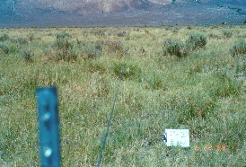
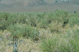
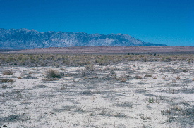
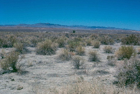
| While Owens Valley now has an arid climate and a wonderful diversity of desert vegetation, tens of thousands of acres on the valley floor historically supported groundwater-dependent meadows. The EIR to the Long Term Water Agreement documented the presence of at least 60,000 acres of alkali meadow, wetland, and desert riparian communities in 1986. Unfortunately, because of the shallow water tables in these areas, they are the sites of many groundwater wells and are vulnerable to desertification. Photo #1 (above left) was taken in 1988 at permanent monitoring site TS2. Total vegetative cover was about 33%, much of which was grass. Photo #2 (above right) was taken in 2004 at the same monitoring site. Total vegetative cover is only about 14%, much of which is shrub cover. Groundwater-dependent grasses are being replaced by dryland shrubs, and total vegetative cover is greatly reduced. | |||
Excessive pumping
In portions of Owens Valley, pumping-induced drawdowns have held water tables below rooting zones of groundwater-dependent vegetation continuously since the LTWA was signed. Field monitoring data, satellite imagery, and repeat photography document the effects of the drawdowns.
The impacts of meadow dessication take the form of lowered cover, loss of perennial grasses, and increases of bare ground and annual exotic species (i.e. weeds, such as tumbleweed) [2]. They are best described as “desertification.” These impacts were not unexpected: DWP itself predicted them in its 1976 EIR [2a]. Hydrologic modeling suggests drawnhttps://ovcweb.org/issues/desertification.html#two-adown water tables are unlikely to recover unless LADWP substantially reduces pumping[3].
In the Big Pine wellfield LADWP violated the LTWA’s prohibition against groundwater-mining in 2004[4]. Under the LTWA, groundwater mining occurs when the volume of the 20 year cumulative annual pumping exceeds the 20 year cumulative estimated annual recharge. The “inherent limitations on pumping” in the LTWA’s vegetation protection requirements were supposed to have prevented pumping from ever approaching groundwater mining limits[5]. Exceeding the mining limit means that during the last 20 years LADWP pumped more than one drop of water for every drop of water estimated to have recharged the Big Pine aquifer.
Valleywide pumping is also excessive. The USGS estimated the long term average annual volume of pumping consistent with vegetation protection requirements of the LTWA to be about 70,000 af/yr[6]. This is based on estimates of vegetation water requirements that may be too low[7], however, so even 70,000 af/yr is probably more pumping than is sustainable. For comparison, during the period from 1970 – 1986 (when LADWP admits pumping impacts occurred), LADWP pumped an average 93,792 af/yr of groundwater. Under current management (1987 to 2005, excluding temporary court-ordered reductions), annual pumping increased to average 95,756 af/yr,[8] and LADWP wants still more.[9]
Excuses
When Inyo County challenged LADWP’s management in the Laws area in 2001, LADWP denied the existence of pumping impacts by challenging the county’s vegetation monitoring protocol. LADWP had agreed to this protocol and not objected to its results for the previous nine years. LADWP also argued that any impacts were due to overgrazing by livestock and a proliferation of vehicle tracks. Vegetation cover has generally increased in un-pumped parcels even though livestock grazing and vehicle use occur there as well as in pumping-affected parcels[10].
When Inyo County challenged LADWP’s 2001–2002 pumping program, LADWP acknowledged no obligation to avoid pumping impacts at all. It acknowledged, instead, only an obligation to mitigate after the fact[11]. The EIR to the LTWA states repeatedly that impact avoidance is a primary goal of the LTWA while mitigation after the fact is secondary[12].
LADWP makes impacted parcels (noted above) disappear by averaging[13]. The LTWA’s vegetation protection goals are expressed in units of homogeneous vegetation called “parcels.” In 2001 LADWP unilaterally decided to assess conditions by averaging vegetation cover values for arbitrary groups of parcels instead of examining parcels individually[14]. High cover values in some parcels cancel out low cover values of impacted parcels. By analyzing data averaged to a coarse, ecologically meaningless scale, LADWP never acknowledges impacted parcels exist.
Finally, LADWP explains overpumping and its impacts by misrepresenting the basic hydrology of the valley. In the arid climate of the Eastern Sierra, annual fluctuations in runoff (which translate to fluctuations of aquifer recharge) are often extreme. Before massive pumping began, however, these fluctuations had little immediate impact on water tables on the valley floor because large springs, surface water bodies, and vegetation served to buffer water tables[15].
Historic data show little correlation south of the Poverty Hills between slight annual changes in water table elevation and enormous annual changes in runoff and recharge [16]. In 1970, however, LADWP initiated massive pumping, dried up springs, killed vegetation[17], and thereby eliminated the buffer to water tables under large areas of the valley floor. Changes in water tables are now correlated with annual runoff and, to an even greater extent, annual pumping. LADWP claims this is “natural.”
It makes the unqualified assertion that water tables decline “naturally” in low-runoff years[18] thereby implying “dry years” are responsible for vegetation declines. Instead of acknowledging the conversion from a buffered to an unbuffered system to be a pumping impact on a grand scale, LADWP claims there are “disagreements between scientists over what the impact of the groundwater pumping is versus the natural change just in the hydrologic cycle.”[19](Italics added.)
 |
 |
||
| Photos #3 and #4 (left and right above, respectively) were taken in 2002 in parcel Laws 52. In 1986 LADWP measured the live vegetative cover of this parcel at about 30%, much of which was grass. The total live cover and grass shrub cover ratio were similar to that shown in photo #1. In 2004, the vegetative cover in parcel Laws 52 was measured at about 9%, of which about half was annual weeds (Russian thistle) and the other half shrub cover. Only a trace of groundwater-dependent grasses were measured, total vegetative cover is greatly reduced, and bare ground increased. Note also the extreme patchiness of the vegetation in the parcel. Increased heterogeneity of vegetative cover is predicted to occur as an impact of pumping-induced water table drawdowns. | |||
What is to be done?
Inyo County has considered initiating another LTWA Dispute Resolution proceeding regarding groundwater pumping and other complaints. This, however, will be expensive and will probably lead to litigation which is even more expensive. Inyo County has limited financial resources, and, as LA Board of Water and Power Commissioner Dominic Rubalcava has thoughtfully pointed out, LADWP’s litigation budget alone exceeds Inyo County’s entire annual budget[20].
Enforcement of the LTWA depends, in the long run, not on litigation, but upon LADWP abandoning its cynical, exploitative management and implementing the LTWA in good faith. We in Owens Valley can document and attempt to publicize LADWP’s abuses, the abuses will cease only occur as a result of political pressure in Southern California.
While it is important to attempt to make DWP comply with the LTWA, the only real solution lies in ending Los Angeles’ addiction to Owens Valley water. Given the fact the LA literally owns most of the valley, the temptation to take advantage of the power imbalance inherent in this colonial relationship is irresistible: it is far less expensive for Los Angeles to continue draining Owens Valley (even at the risk of occassional litigation) than it is to invest in infrastructure changes necessary for large scale water recycling and conservation in Los Angeles. In 2013 there are now a few groups in LA calling for an end to dependence on imported water. Unless/until these groups can somehow succeed, there is little hope for Owens Valley.
–Daniel Pritchett
Notes
1.
City of Los AngelesDepartment of Water and Power and County of Inyo. 1990. Water from the Owens Valley to supply the second Los Angeles aqueduct 1970 to 1990, 1990 onward pursuant to a long term groundwater management plan. Draft Environmental Impact Report. SCH#89080705. (Cited below as “LADWP DEIR 1990”)
Acreages of groundwater-dependent vegetation are given on pp. 10-12 to 10-19. Goals of the LTWA are summarized on pp. S-5 to S-6.
2.
Manning, S.J. 2004. Status of re-inventoried vegetation parcels according to the Drought Recovery Policy, 2003. Inyo County Water Department. May 26, 2004. pp. 22-23. See report at ICWD site. (Cited below as “Manning 2004 Status Report”)
Manning identifies 26 parcels with unrecovered water tables and impacted vegetation. Not all vegetation parcels are monitored, however, so the total number of impacted parcels is unknown.
Elmore, A.J., J.F. Mustard, and S.J. Manning. 2003. Regional patterns of plant community response to changes in water: Owens Valley, California. Ecological Applications, 13(2): 443-460.
Rossi, D. 2004. Big Pine falling victim to too much groundwater loss. Letters to the Editor. Inyo Register. May 27, 2004.
Rossi attributes death of locust trees to groundwater pumping. While his observations are anecdotal, it is entirely likely that some Owens Valley trees have been impacted by drawdowns. Because required monitoring of stands of willows and cottonwoods (LADWP. 1990. DEIR p. S-6) has never been conducted, however, it is unlikely there will be data to support attribution of tree deaths to drawdowns. Some of the most visible apparent pumping impacts are thus the least likely to be acknowledged, much less mitigated.
2a.
Los Angeles Department of Water and Power. 1976. Final Environmental Impact Report on increased pumping of the Owens Valley groundwater basin.
Table B-1 and the accompanying discussion on pages B-6 – B-9 predict loss of grass cover, development of “alkali barrens” an increases of annual weeds, such as Russian thistle.
3.
Steinwand, A. and R. Harrington. 2003. Simulation of water table fluctuations at permanent monitoring sites to evaluate groundwater pumping. Inyo County Water Department. February 25, 2003. See it on the web
Simulations in this study showed chances of water table recovery to rooting zones (as explicitly required in the EIR to the LTWA) at most monitoring sites are virtually nil with current volumes of pumping.
4.
James, G. 2004. Letter to Gene Coufal. Groundwater pumping from the Big Pine wellfield and the Laws wellfield. November 8, 2004. Released by Inyo County Water Department.
5.
City of Los Angeles Department of Water and Power and County of Inyo. 1990. Water from the Owens Valley to supply the second Los Angeles aqueduct 1970 to 1990, 1990 onward pursuant to a long term groundwater management plan. Draft Environmental Impact Report. SCH#89080705. Response to comments. Vol I. pg. 2-23. (Cited below as “LADWP. 1991. Response to Comments”)
6.
Danskin, W.R. 1998. Evaluation of the hydrologic system and selected water-management alternatives in the Owens Valley, California. US Geological Survey Water-Supply Paper 2370-H. pg. 2. See report at USGS site (Cited below as “Danskin. 1998. Hydrologic Evaluation.”)
Danskin gives a figure of 75,000 af/yr which includes flows from artesian wells. When these flows are decremented, the total sustainable pumping comes to around 70,000 af/yr.
7.
Steinwand, Aaron. 2000. The effects of Kc and Green Book models for vegetation water requirements on permanent monitoring site On/Off status. Report submitted to the Inyo/LA Technical Group. April 24, 2000.
8.
Los Angeles Department of Water and Power. 2004. Annual Owens Valley operations plan for runoff year 2004-2005. pg. 3-2, Figure 10, bottom panel in: Los Angeles Department of Water and Power annual Owens Valley report 2004-05 runoff year. See report at ICWD site. (Cited below as “LADWP. 2004. Operations plan.”)
While the EIR to the LTWA was not complete until 1991, LADWP began cooperative management with Inyo County in the mid-1980s, as mentioned by Jerry Gewe in the interview cited in note #19 below. LADWP thus averages its pumping into periods from 1970-1986 and 1987 through the present.
9.
Kelly, W.J. 2004. Money in the lake. LA Weekly, April 30 – May 6, 2004.
In this article, Jerry Gewe is reported to have already told the LA Board of Water and Power Commissioners that he hopes to pump more water in Owens Valley. The article also discloses the connection between LADWP’s excessive pumping of central Owens Valley and its obligation to provide water to abate dust on Owens Lake.
10.
On October 13, 2001 Inyo County initiated a Dispute Resolution proceeding based on the need to avoid impacts to vegetation at Laws and LADWP’s refusal to run the McNally canals according to historic practice. Arguments cited in the body of this article come from the legal documents pertaining to this dispute. Legal documents are available from the Inyo County Water Department. Data regarding cover in un-pumped vegetation parcels are in Manning. 2004. Status Report.
11.
City of Los Angeles Department of Water and Power. 2001. Reply to Inyo County Water Department Comments Dated May 18, 2001 and Transmittal Letter Dated May 2, 2001. Document submitted to Inyo County Water Department. June 1, 2001. pg. 2.
LADWP wrote, “In short, the Agreement requires the City to consider impacts of its groundwater pumping before implementing the annual plan, but does not authorize Inyo to restrict or limit the City’s pumping before the fact. The Agreement instead sets forth the method of determining after the fact whether an impact to vegetation has occurred which is measurable, significant, and attributable to groundwater pumping.” (italics added). Note that the LTWA’s requirement to “avoid” impacts is reduced by LADWP to a requirement to merely “consider” impacts. LADWP has never publicly explained how keeping water tables permanently below rooting zones of groundwater-dependent vegetation is consistent with its requirement to avoid significant impacts.
12.
LADWP. 1990. DEIR. pp. S-6 and 10-70. LADWP. 1991. Response to Comments. Vol I. pp. 2-58, 2-69.
13.
LADWP. 2004. Operations plan. Pg 3-2, Figure 9, third panel down; pp 3-13 – 3-18.
In the discussion of vegetation conditions in this document the word “parcel” is not used. The “wellfield” averages presented in the report are irreproducible results. They cannot be independently calculated because neither the parcel data nor the wellfield boundaries upon which averages were based are specified.
14.
.
Los Angeles Department of Water and Power. 2001. Drought Recovery Policy Evaluation Report. April, 2002. Brochure mailed to Inyo County residents.
The brochure contains a summary of findings in Montgomery Watson Harza’s 2001 drought recovery policy evaluation report, available at www.laaqueduct.com. The brochure also gives average vegetation cover values for undefined areas called “wellfields.” As in note #13 above, wellfield boundaries are not specified, nor are the parcels included in the wellfield averaging which makes independent analysis and verification of results impossible.
15.
Danskin. 1998. Hydrologic Evaluation. pg. 137.
16.
Lee, Charles H. 1912. An intensive study of the water resources of a part of Owens Valley, California. Water Supply Paper 294. Department of the Interior United States Geological Survey. Government Printing Office, Washington, DC.
Lee gives water table data for 1909-1912, before massive pumping began. There were pulses of pumping in the 1920s and early 1930s, but LADWP’s records indicate there was no pumping from 1936 through 1959. Some test wells were monitored throughout this period, and data from these wells, in conjunction with Lee’s, are the best quantitative data for examining “natural” subsurface hydrology.
17.
LADWP 1990. DEIR. pp. 9-35 – 9-36 and 10-54 – 10-76.
18.
Los Angeles Department of Water and Power. 2002. Annual Owens Valley operation plan, 2002-2003 runoff year. April 20, 2002. pg 1.
Los Angeles Department of Water and Power. 2001. Annual Owens Valley operation plan, 2001-2002 runoff year. May 9, 2001. pg 1.
19.
Metro Investment Report. 2004. LADWP’s Water Guru, Gerald Gewe Opines On Owens Valley, Water Marketing and Desal. January 2004 edition. See article on the web Gewe’s responses to the first and second interview questions are masterpieces of spin. In a few sentences he gives the impression that “third parties,” i.e., environmental groups are preventing LADWP from implementing mitigation measures.
He also invokes both the “dry years” and the “natural variation” excuses for excessive pumping. LADWP’s success in getting the public to focus on “dry years” (instead of pumping-induced draining of hydrologic buffers) is illustrated in the Kelley article cited in note #9. In Kelley’s article, Inyo County Water Department Director Greg James and other valley residents are reported to have said that vegetation is dead “because the water table drops below the roots of plants and trees in dry years.” (italics added)
20.
Rubalcava’s boast was reported by Inyo County Water Department Director Greg James at the October 8, 2001 meeting of the Inyo County Water Commission.

